

![]()
![]()
![]()
![]()
![]()
![]()
TRACING WATER MOVEMENT IN UNSATURATED SOILS AT THE PALO VERDE NUCLEAR POWER PLANT SITE WEST OF PHOENIX, ARIZONA, U.S.A.
William M. Turner, Ph.D.
INTRODUCTION
The determination of water saturation of oil-bearing rock utilizing neutron logging is a well-known, down-the-hole geophysical logging technique. Less well known is the use of neutron logging for the quantitative determination of volumetric soil-moisture content.
This case study report presents some of the data obtained from a simulated leak in a lined, wastewater-retention pond at the Palo Verde Nuclear Power Plant site near Buckeye, Arizona. The wastewater-retention pond is situated on level alluvial terrane.
PROCEDURE
|
|
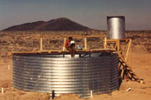
We backfilled the annular space between the PVC casing and the natural soil with dry bentonite drilling compound to prevent behind-the-pipe, vertical leakage of water. We filled the tank a depth of seven feet (2 m) with water and allowed it to infiltrate through the bottom. We maintained a constant head of seven feet (2 m) of water by automatically adding water to the tank to replace water lost by infiltration and evaporation.
|
|
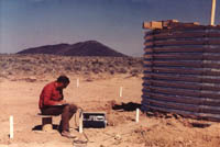
Prior to filling the tank and at intervals following the filling, which extended over a six-month period, AGW scientists logged each observation hole with a Troxler soil-moisture neutron probe. We processed the neutron-probe data provide the following output for each hole and for each day for which data was acquired.
• Volumetric moisture content of the unsaturated zone
• Graphical display of the volumetric moisture content with depth
• Cumulative change of moisture content from pre-test conditions
• Graphical display of the change in volumetric moisture content with depth
From this data, we prepared north-south and east-west cross sections which show the distribution of soil moisture below and adjacent to the tank resulting from the infiltration of water from the bottom of the tank.
RESULTS
A sample data set is given in Table 1. The observation hole for which data is given is located in the center of the tank. From this data, we calculated the vertical hydraulic conductivity of the earth in the unsaturated zone was calculated to be 5.0 x 10⁻⁶ cm/sec.
We also determined that the area of saturation extended away from the circular tank about 20 feet (6 m) in all directions. At the end of six months, water had only penetrated to a depth of about 19 feet (5.8 m) and further advancement of the wetting front was very slow. We believe that the capillary attraction of the soils and the negative matric potential ultimately matched the driving head of water.
CONCLUSION
The use of a neutron probe for quantitatively measuring the movement of water in unsaturated soils is a rapid and accurate method for evaluating potential seepage problems. The method is applicable to quantitatively monitoring.
The techniques described here are also applicable to monitoring moisture movement in:
• Tailings dumps
• Heap leaching
• Land fills
• Feedlots
• Irrigation projects
• Earthen dam embankments
• Liquid sludge disposal facilities
• Surface-water recharge facilities
• Waste-water retention ponds
![]()
![]()
![]()
![]()
![]()
![]()
? 1999 - 2016 AGW Consultants. All Rights Reserved.